SOME GUIDELINES ABOUT THE GEOLOGY OF JORDAN:
- Jordan lies at the northern rim of the African-Arabian Precambrian granitic shield (more than 600 million years). This continental crust was submitted over time to fluctuating vertical motions, allowing sea intrusions when it was down and mountains formations and erosion when it was up.
- Over this Precambrian Basement rock, that appears in the Aqaba region, we find a 1800 m thick sediment of Paleozoic sandstone and shale (570 – 280 million years) of marine and continental origins. 190 million years ago, the sea regressed and let room to erosion.
- Around 165 million years, the sea invaded again the area, first the southern Rift Valley till near the Wadi Zarqa (Yabbok), and then (around 100 million years) flooded over extensive areas (phenomenon called transgression) depositing sediments accumulated in basins particularly along the Wadi Araba Jordan Rift Valley and in the al-Jafr and al-Azraq Wadi Es-Sirhan Basins.
- From 65 million years (Cenozoic), sediments deposited and formed swells (domed areas) and basins systems. Wadi Araba collects sediments coming from the rock erosion of the lateral valleys (clastic sediments). Locally, in the central parts of the graben, thick rock salt was deposited in the Oilgo-Miocene to Pliocene (36-12 million years). During the Cenozoic area, the Jordan Rift Valley was either occupied by fresh water lakes, or formed an inland depression with terrestrial or lacustrine sediments or was flooded by sea water. Those transgressions reached eastern and north areas during the Miocene (23 - 5 million years).
- During the Miocene and Pliocene (23 - 2,5 million years), the Mediterranean Sea was linked to Wadi Araba Jordan Rift through the Beisan Depression and even may have linked with Aqaba Gulf.
- Throughout the Quaternary (2.5 million years till now), the Azraq and Jafr depressions were partly covered with fresh water lakes and fluvial systems. Fluviatile conglomerates of the same age spread over wide areas along the eastern slopes of the mountain ridges bordering the east side of the Wadi Araba - Jordan Rift.
 | Between 70 000 and 12 000 yeas ago extended a lake in the Jordan Valley, called Lisan Lake. The sediment formations left by the lake extend from Tiberia Lake till the South of the Dead Sea. The lake left behind a layer of lacustrine sediment that blankets the Jordan Valley with terraces of sediment up to 40 m thick. |
Tectonic map of Jordan: click here to extend 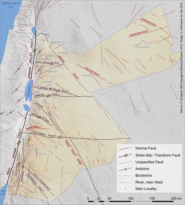 | The East Mediterranean region is the place where three major tectonic plates : Africa, Arabia, and Eurasian Anatolian Sub plate, face each other. Jordan covers the north-western part of the Arabian plate separated from the African Plate by the Jordan - African Rift Valley, which is the deepest fracture of the earth crust, 7000 km long (from Tiberia Lake to Mozambique). As the Arabian plate is pivoting northwards, Red Sea is widening. The western side of the Arabian plate is submitted to a friction with the Sinai-Palestine subplate in an inverted motion that provoke the elongation of the Dead Sea Basin. Consequently, the region can be affected by earthquakes has been subject to earthquake disasters during the past two thousand years that has left great losses in terms of life and material damage, what can be easily noticed in the archaeological records. (See map here) | 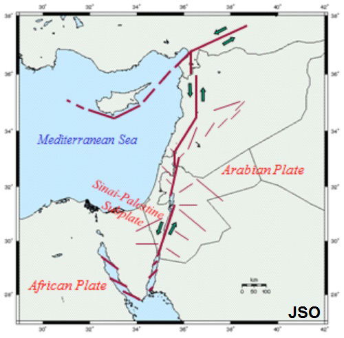 |
The geological structure of Jordan shows the effect of several phases of deformation since the Cambrian period (541 to 485 millions years). Those movements resulted in gentle, regional tilting, uplift and combinationS of faulting and folding. According to the different kinds of structural deformations and patterns, the country can be divided into three major structural parts:
The Nubo-Arabian Shield of South Jordan.
The Block-Faulted Platform of Jordan east of the Rift.
The Wadi Araba - Jordan Rift
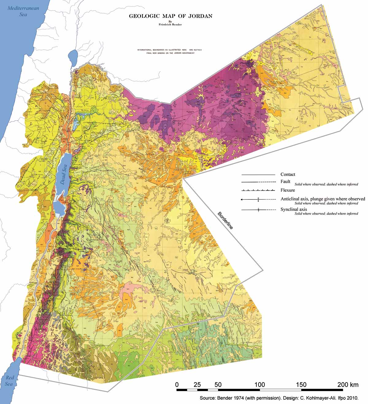
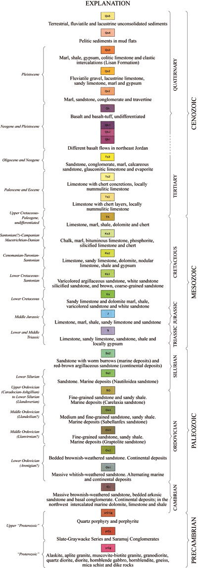
The below map shows in details the geological structures of Jordan. Use the horizontal scroll down the map to see the explanations on the right.
Reference: Kamal Jreisat, Tawfiq Yazjeen: https://books.openedition.org/ifpo/4861